About Us
Our Communities
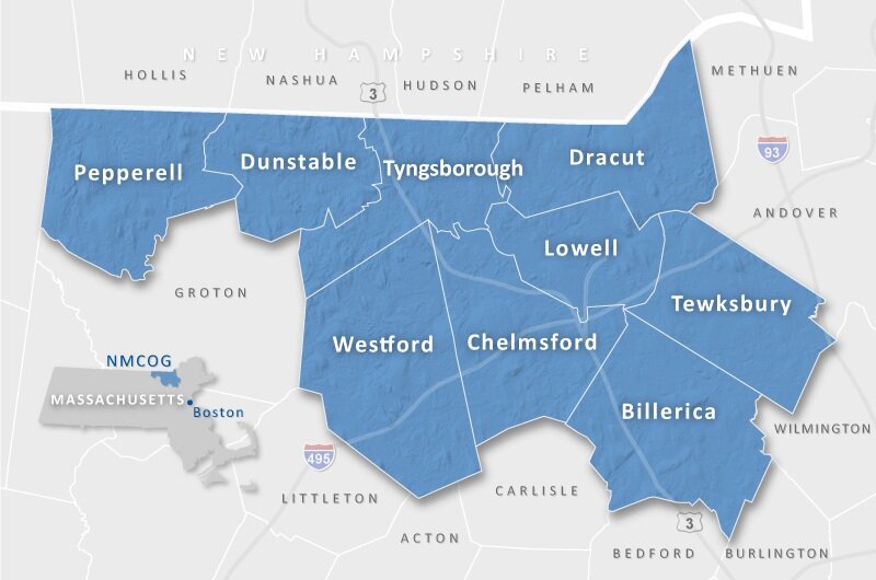
The Northern Middlesex region encompasses 196 square miles in northern Middlesex County, approximately 20 miles north of Boston, Massachusetts. The member communities include the City of Lowell and the Towns of Billerica, Chelmsford, Dracut, Dunstable, Pepperell, Tewksbury, Tyngsborough, and Westford. The region is home to 310,009 persons, according to the 2020 U.S. Census.
The region contains innumerable natural resources, including wetlands and waterways, forest, fields, farms and hilltops. Such resources are critical to the overall character of the region, and to the quality of life for its residents.
The Greater Lowell region has a diverse economy, extensive infrastructure, and a highly educated and well trained workforce. The principal higher education facilities serving the region include UMass Lowell and Middlesex Community College. Both institutions provide employment, education opportunities, and research and development initiatives that help the region grow economically.
Our Communities
Billerica
Billerica was incorporated in 1655 and has a total land area of 25.96 square miles with a 2020 population of 42,119. Billerica is governed by a Representative Town Meeting comprised of 240 voting members. A five-member Select Board serves as the executive body and the Town Manager serves as the Chief Administrator.
Town website: www.town.billerica.ma.us
Billerica data: Billerica Municipal Summary (2020 Census Data)
Chelmsford
The Town of Chelmsford was incorporated in 1655 and has a total land area of 22.8 square miles with a 2020 population of 35,488. Chelmsford is governed by a Representative Town Meeting. A five-member Select Board serves as the Town's executive body and the Town Manager serves as the Chief Administrator.
Town website: www.townofchelmsford.us
Chelmsford data: Chelmsford Municipal Summary (2020 Census Data)
Dracut
Dracut was incorporated in 1701 and has a total land area of 20.8 square miles with a 2020 population of 32,617. Dracut is governed by an Open Town Meeting. A five-member Board of Selectmen serves as the Town's executive body and the Town Manager serves as the Chief Administrator.
Town website: www.dracutma.gov
Dracut data: Dracut Municipal Summary (2020 Census Data)
Dunstable
Dunstable was incorporated in 1673 and has a total land area of 16.74 square miles with a 2020 population of 3,358. Dunstable is governed by an Open Town Meeting. A three-member Board of Selectmen serves as the executive body assisted by the Town Administrator.
Town website: www.dunstable-ma.gov
Dunstable data: Dunstable Municipal Summary (2020 Census Data)
Lowell
The City of Lowell was founded in 1826 as a planned industrial city and incorporated in 1836. With a population of 115,554, Lowell is the fourth largest community in the Commonwealth. Lowell follows a Plan E form of government with nine at-large City Councilors elected to serve two-year terms. The City Council elects a mayor from its members to serve as mayor and preside over the City Council and School Committee.
City of Lowell website: www.lowellma.gov
Lowell Data: Lowell Municipal Summary (2020 Census Data)
Pepperell
The Town of Pepperell is situated 35 miles northwest of Boston at the junction of the Nissitissit and Nashua Rivers adjacent to the New Hampshire border. Pepperell was incorporated in 1775 and has a total land area of 22.99 square miles with a 2020 population of 11,604. Pepperell is governed by an Open Town Meeting with a three-member Select Board assisted by the Town Administrator.
Town website: www.town.pepperell.ma.us
Pepperell Data: Pepperell Municipal Summary (2020 Census Data)
Tewksbury
The Town of Tewksbury is bordered by the City of Lowell, Dracut, Andover, Wilmington, Billerica and Chelmsford. The Town was incorporated in 1734 and has a total land area of 20.7 square miles with a 2020 population of 31,342. Tewksbury is governed by an Open Town Meeting with a five-member Select Board and Town Manager.
Town website: www.tewksbury-ma.gov
Tewksbury Data: Tewksbury Municipal Summary (2020 Census Data)
Tyngsborough
The Town of Tyngsborough is located 28 miles from Boston and is bordered by Chelmsford, Dracut, Groton, Lowell, Dunstable, Westford and Nashua, New Hampshire. The Town was incorporated in 1809 and has a total land area of 18.05 square miles with a 2020 population of 12,380. Tyngsborough is governed by an Open Town Meeting with a five-member Board of Selectmen and Town Administrator.
Town website: www.tyngsboroughma.gov
Tyngsborough Data: Tyngsborough Municipal Summary (2020 Census Data)
Westford
The Town of Westford is located along I-495 and U.S. Route 3. Westford was incorporated in 1729 and has a total land area of 31.33 square miles with a 2020 population of 24,643. Westford is governed by an Open Town Meeting with a five-member Select Board and Town Manager.
Town website: www.westfordma.gov
Westford: Westford Municipal Summary (2020 Census Data)

